General Description Location
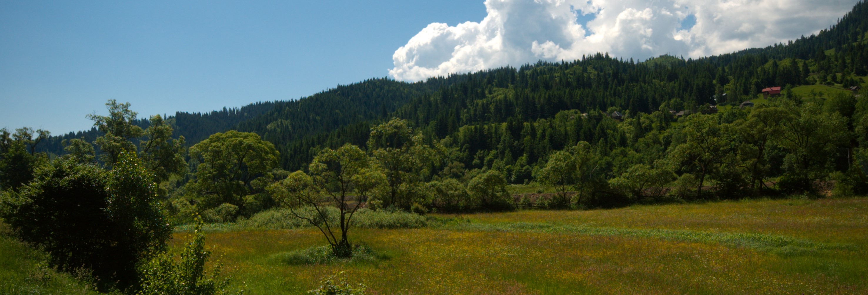
The Defile of Mures Nature Park is located within the administrative territory of Deda, Rastoli?a, Lunca Bradului and Stânceni communes, Mures County, and spans an area of 9156 ha.
The Deda-Toplita pass is 33km long and it represents the limit between the Calimani Mountains and the Gurghiu Mountains - volcanic mountains in the central group of the Eastern Carpathians.
The Calmani and Gurghiu Mountains, situated at N and S of the Mures Pass belong to the South East compartment of the neogene (neocene) volcanic chain Oas - Gutâi - Tibles - Calimani - Harghita.
The Defile of Mures connects the Depression of Giurgeu to the Transylvanian Plateau, being the longest cut through the volcanic chain in our country. The very tight portions, with high and steep slopes, with various alluvial fans made of volcanic blocks.
Map
History
Law no. 5 of 6th of March 2000 concerning approval of the Plan of arranging the national territory - section III - protected areas1, appendix 1, article1, point2 no. 2638, the Deda - Toplita Pass (with a surface of 6000 ha) and no. 2639, the Mures Defile, (with a surface of 7733 ha) were designated protected areas. Decision no. 1143 of 18 September 2007 concerning establishment of new protected natural areas, the Defile of Mures Nature Park - with a surface of 9156 ha - was designated as such. The Commission for Preserving Natural Monuments notified it as such with no. 1.098/CJ/25.04.2006 B, 1.752/4.04.2006.
Limits
Northern limits
It starts on the right bank of the Mures River and it continues on the Bistra stream until the confluence with the first tributary that flows down from Ple?a Bistrii. The limit continues ascending towards the North East on the stream line until it reaches the forest (landmark 246), turns east and ascends on the confluence of the Bistra Valley and Sterinoasa (the 595 m mark), but it leaves the peak toward north and it goes around the origin of the Sterionasa stream, reaching the forest (landmark 245). It goes on following the forest limit until it reaches the Sterionasa peak, takes to north (forest landmarks 244, 3), it descends in the Corb Valley (landmarks 4, 8), ascends again on the opposite slope (landmark 7) and continues on the secondary peak until it reaches the Galaoaia Valley (landmark 13). Further on, the limits ascends towards east, on the peak that marks the limits of the Mures valley, with various slopes (landmarks 156, 163, 174), the Ulm peak (927 metres), the Visa valley (landmarks 185, 216, 215, 3, 2), Porc stream, goes on to the limit with the Rastolita forest, the Porcu peak (landmarks 26, 23, 32) and it descends on the Rastolita valley at the end of Rastolita county (landmark 410). The limit goes after the Răstoliţa valley and it goes by the Bannfy stream on a well defined slope (landmarks 457, 456), until it reches the peak that ”shields” the Mureş valley, goes by the Fântânel peak – 1070 meters (landmarks 479, 501), the Sărăcin peak – 1043 meters (landmarks 502, 515), follows the forest’s limit with the Lunca Bradului grazing and it reaches the Runc peak. Further on, the limit descends to the forest skirt (landmarks 68, 62) and on the secondary peak that goes after the Mureş valley, descends to the Bisericii stream (landmarks 60, 43, 56, 57), ascends to the peak and it descends to the Fântânel stream (landmarks 82, 34), ascends again on the Ilva stream until it reaches the confluence of the Ilva and Ungurasu streams (landmark 765). From this particular point forward, the limit ascends through grazing on a secondary peak, follows the forest skirt (landmarks 759, 754, 745, 739) until it reaches the hayfields around the Neagra peak (1122 meters). From the peak, the limit descends to the Neagra Călin stream (landmarks 836, 838), then goes up towards the south east on the peak (landmarks 887, 901) and descends again to the Niculeşti stream (landmarks 902, 930). It continues by ascending to the secondary peak, passing through landmarks 931, 927, 919 reaching the grazing on the peak and descends on the interfluves between the Borţa and Zebrac streams, until it reaches the interfluve’s thalweg (landmarks 13, 9, 351, 340). From this point forward, the limit ascends, following the secondary peak on the Mureş valley, passing through the Leu peak (1147 meters), and then descending towards the south east on the peak (landmarks 138, 137, 136, 134, 135, 148, 208, 193), until the Mermezeu stream in the region where the forest road and the road to the stone pit intersect. It goes on by ascending towards the east on the secondary peak, continues above the pit’s upper wall and it reaches the Drăgăşel peak (938 meters), descends in the Duşa stream (landmarks 288, 287, 291, 295), then again ascends to the Piatra peak (landmark 332).
Eastern limits
The limit descends on the Piatra peak (the administrative limit of Mureş County) to the Mureş river (landmark 336), crosses the river and ascends through grazing on the Ciobotan peak, following the forest skirt (landmark 314, 315), crosses the Ciobotani stream until it reaches the Gliga Hill (973 meters).
Southern limit
It descends from Dealul Glighii to theNorth West, follows the forest skirts (landmarkd 330, 325), until it reaches the confluence of Gudea Mică and Gudea Mare streams (landmarks 326, 600). Then it goes up towards the west through the forest on a secondary peak (landmarks 603, 616), crosses Bătca Gudea (1113 meters), the upper edge of the Dealul Zbanghii and it ascends on the Maguricea peak (1016 meters) on the forest limit under Poiana Şestina Mare (landmarks 307, 314). From this point forward one needs to follow the peak that goes down towards north west to the Meştera strem (landmarks 318, 324, 330), then ascending towards the south west through the Meşterului grazing on the confluence of Jingul and Meştera. Further on, the limit turns to the north until it reaches the limit of the protective forest (landmark 359), then it turns north west to the 975 m mark and descends to the Jangul stream (landmarks 364, 365). There comes a slope towards south west on a secondary peak, descends to thenorth weston the confluence of Jangul and Neagra to the Neagra între Craci stream (landmarks 398, 397, 418, 417). From here on, the limit turns south west and following the forest skirt reaches the Dealul Doamnei, turns north west still on the forest skirt until the 444 landmark and descends to the Iadului stream (landmark 445), ascending then on the Piciorul Lung peak (landmark 451). Later on, the limit descends on the confluence of streams on the limit of the forest fund, crosses the Arsita and Gyarfas streams until it reaches the Lunca Bradului peak (905 meters) (landmarks 452, 458, 466, 468, 471, 472, 501, 502). The limit descends on the Bufantau stream, ascends and descends to the Sălard stream (landmarks 482, 505, 485, 491, 490). From the Sălard valley (landmark 484), the limit turns south west ascending to the top on the Hiclean peak – 1024 meters (landmarks 484, 485, 489), descends on the Corbului peak to landmark 2, to the Pescoasa Mare stream (landmark 3), goes up on the Pescoaselor peak and descends to the Pescoasa Mică stream (landmarks 28, 38, 39), ascends to the Plaiul Borţii peak (1082 meters) (landmarks 43, 42). The limit goes on towardsnorth weston the interfluve between the Mureş and Iod tanks, Listeş peak – 1062 meters and on the plaiul Iodului until the Iod valley (landmarks 122, 99, 105). From this point forward the limit ascends on the Iod valley, it follows a secondary peak on the Lespedea left interfluves (landmarks 233,241) and descends to the big forest (landmark 237); from there to the Costeasa stream (landmark 246). It goes on by ascending on the peak towards west, turns to the south west and ascends to the 766 meters mark (landmark 250), then on the peak between the Mureş reservoir and the Borzia reservoir, to the confluence with Zăpodia Arsura (landmarks 7, 8), ascends on the Zăpodia Pleşilor (landmark 46) and after meeting the first tributary it turns to the west and, after ascending a secondary peak it reaches the Făgeţel peak – the peak between Mureş valey and Borzia valley, under plaiul Borzia (landmarks 51, 52, 65).
Western limits
The western limit starts from the peak between Mureş valley and Borzia valley, descends on the secondary peak until the forest limit (landmark 68) and it follows the forest fund limit and a stream until it reaches the Mureş river (landmarks 69, 53, 54, 56), it follows the left shore of Mureş river until it reaches the confluence with the Bistra stream.
Internal zonal division
The internal zonal division regarding the necessity of preserving the biological diversity shall be made according to the management plans (in 9 months from the ceasing date of the management contract) according to the provisions in art. 22, paragraph (1) of the Government’s Emergency Ordinance, no. 57/2007 - concerning the natural protected areas’ regime, preserving natural habitats and wild flora and fauna.
Physical environment
Pedology
As a last major geodynamic process which led to the formation of the Oriental Carpathians, this volcanic chain is made of subduction vulcanites with a mainly andesitic composition but all types of volcanic rocks from rhyolites to basalts are met here.
The types of soils, which were formed due to climatic conditions with an influence on the variations in altitude, relief divisions, the land’s inclination, the dominant exposure, are:
- Typical brown soil – dominant in the beech forest area in Sebeş, Iod, Gălăoaia
- Dystric Cambisols – dominant in the entire pass; this type of soil is massive in the regions of Androneasa, Ilişoara, Neagra, Meştera, între Gudea and Lunca Bradului
- Andi-lepti-dystric Cambisols
- Lepti- dystric Cambisols – locally in the Androneasa and Lunca Bradului areas
- Lepti-eutric Cambisols – locally in the Androneasa area.
Quitting the pass, on pastures and hayfields, we find grey soils with low content in humus, situated on argillaceous substrates.
Hydrology
Within the pass, the depth of the water varies from 0.6 to 3 meters. Water speed varies depending on debit and on the slope’s value; there are areas where the current’s value is 0.6 m/s but the speed does exceed 1.5 m/s in certain places.
In the Topliţa – Deda pass, the river’s basin is relatively symmetrical. The Mureş river’s bed can be divided in 3 parts with different features.
Between the Topliţa and Sălard valley, the width of the valley can reach even 800 meters; we can spot layered terraces and the tributaries form individualized alluvial cones. The minor riverbed is rather tight (less then 50meters), with alluviums formed of coarse gravel and in the meanders – little beaches made of tiny gravel and coarse sand. At the confluence of the Mureş river with larger streams we spot depressions caused by erosion, formed by less course rocks (Stânceni, Neagra, Ilva).
Between Sălard and Răstoliţa the valley becomes tight, the slopes are steep, supplying the riverbed with cliff blocks and rocks, confering the alluviums a coarse character. Here the water current is faster due to various thresholds, with deeper areas.
From Răstoliţa, the valley widens again, the major riverbed becoming really wide and the minor riverbed is formed of gravel and rocks. The valley presents backwater portions, which alternate with tight portions, depending on how close the slopes are. At Răstoliţa the basin reaches 1 km in width. The last tributary of the Mureş river, coming from theCălimaniMountains, Bistra Mureşului, also defines the downstream limit of the pass; from this point forward, the river enters the Transylvanian Depression.
Climate
The average annual temperature ranges from 5.390C at Topliţa and about 7.20C at Gălăoaia. The snow layer last generally about 100-120 days, from November to March – April; its thickness generally varies between 20 – 35 cm.
The winds, a characteristic feature of mountain passes, have a high frequency and the average annual speed is about 30km/h, often exceeding 3.8m/s.
Biotic environment
Flora and vegetation
The ground vegetation is dominantly made of mesophyllic mountain species, lightly acidophilous mesothermal species and neutral species.
Most of this territory is covered with beech, spruce fir and fir forests. The influence of the air currents is noticeable – the climate is colder and wet and the associations of vegetal structures also mirror the specific air currents. Thus, even though mixed forests (evergreen and leafy forests) are predominant, upstream from Lunca Bradului, spruce fir is met in certain places even at an altitude of 600 meters; an extrazonality of spruce fir associations is met. Beech forests lay on wide surfaces around Răstoliţa and Bistra Mureşului. The herbaceous layer is luxuriant, including species as: Dentaria glandulosa, Symphytum cordatum, Ranunculus carpaticus. The most beautiful spruce fir regions with Leucanthemum waldsteinii are found around Lunca Bradului and Stânceni. Given the lack of light in the herbaceous layer, the herbaceous species vegetate mostly at forest edge; for example: Aconitum moldavicum, Hieracium rotundatum, Pulmonaria rubra.
Everglade forests are present almost all along the pass near the Mureş river. Upstream from Lunca Bradului forests species with Salix (Salix triandra, S. viminalis, S. pentandra) being mostly predominant. Downstream from Lunca Bradului, the clusters are bigger and the predominant species are Alnus glutinosa and Alnus incana. The most spectacular alder forests are those having Matteucia strutioperis in their herbaceous layer, around Androneasa and Răstoliţa.
In the places where the pass is excessively narrow, the forest is replaced by everglade weed with a few species of willow and alder. These tall herbaceous plants have a rich variety of species, many of them having big flowers and a decorative aspect and representing a specialty of the landscape – as for instance: Telekia speciosa, Filipendula ulmaria, Chaerophyllum hirsutum subsp. Glabrum, Carduus nutans, Cirsium erisithales, Thalictrum aquilegifolium.
Within the landscape of the pass we can also spot the cliff vegetation. The cliffs and the cliff walls which appeared after the national road was built represent large surfaces on the right slope of Mureş. The cliff specific vegetation of the pass is very rich.
The number of categorized floral elements so far in the pass represents about 30.88% of the species known in our country’s flora. The best represented families in the plant-world are: Asteraceae (136), Poaceae (71), Rosaceae (53), Lamiaceae (49), Cyperaceae (47), Brassicaceae (43), Fabaceae (41), Apiaceae (40), Scrophulariaceae (38), Ranunuculaceae (35), Caryophyllaceae (34) and Orchidaceae (21) (Oroian 1998). These 12 families make up the basis of the floristic overview of the studied territory, representing 60.09% of all the identified taxons.
In the pass there are 15 rare and endangered species.
Angelica palustris, Arnica montana,Calla palustris, Carex chordorrhiza,Cicuta virosa, Dianthus barbatus ssp. Compactus, Hyoscyamus niger, Laser trilobum,Laserpitium krapfii, Oenanthe aquatica, Polemonium caeruleum, Silene armeria, Streptopus amplexifolius, Trollius europaeus, Woodsia ilvensis, Thymus comosus (Oroian 1998).
Fauna
The fauna is rich in species, the rate of rare or endangered species being rather high.
The presence of various species has been also noticed along the evaluation of large carnivores. Others are identified through the carnivores’ excrements (wolf, otter, etc.).
The species in the avifauna of the pass can be divided into two big species: brooding birds and those birds which have been noticed occasionally or winter visitors.
In the last four decades (1945 – 2005), in the Mureş Defile there were noticed 95 species (73.64% out of all) of brooding or probably brooding birds (offspring in the nesting period have been noticed) and 34 (26.35%) species noticed accidentally or as winter or summer visitors; data about their nesting is missing.
The piscicultural fauna of the Mureş, in the pass is very diverse and well represented.
The Mureş river is among the few mountain rivers in our country which are favourable for growing Salmo Hucho – a type of large salmon.
Communities
The surface of the Defile of Mureş Natural Park lies on the administrativeterritoryofStânceni, Lunca Bradului, Răstoliţa, Deda inMureşCounty.